Search Results for author:
Found 18 papers, 9 papers with code
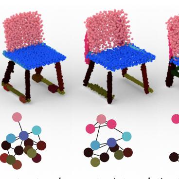
Compositional 3D Scene Synthesis with Scene Graph Guided Layout-Shape Generation
Recent progresses have been made in shape generation with powerful generative models, such as diffusion models, which increases the shape fidelity.

Convincing Rationales for Visual Question Answering Reasoning
Visual Question Answering (VQA) is a challenging task of predicting the answer to a question about the content of an image.

BuilDiff: 3D Building Shape Generation using Single-Image Conditional Point Cloud Diffusion Models
3D building generation with low data acquisition costs, such as single image-to-3D, becomes increasingly important.

Interactive Image Segmentation with Cross-Modality Vision Transformers
Interactive image segmentation aims to segment the target from the background with the manual guidance, which takes as input multimodal data such as images, clicks, scribbles, and bounding boxes.
Channel-Aware Distillation Transformer for Depth Estimation on Nano Drones
Autonomous navigation of drones using computer vision has achieved promising performance.

HRVQA: A Visual Question Answering Benchmark for High-Resolution Aerial Images
Visual question answering (VQA) is an important and challenging multimodal task in computer vision.
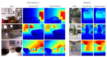
Lite-Mono: A Lightweight CNN and Transformer Architecture for Self-Supervised Monocular Depth Estimation
Self-supervised monocular depth estimation that does not require ground truth for training has attracted attention in recent years.
 Ranked #4 on
Unsupervised Monocular Depth Estimation
on KITTI-C
Ranked #4 on
Unsupervised Monocular Depth Estimation
on KITTI-C
 Monocular Depth Estimation
 Unsupervised Monocular Depth Estimation
Flow-based GAN for 3D Point Cloud Generation from a Single Image
Generating a 3D point cloud from a single 2D image is of great importance for 3D scene understanding applications.
Bidirectional Multi-scale Attention Networks for Semantic Segmentation of Oblique UAV Imagery
Semantic segmentation for aerial platforms has been one of the fundamental scene understanding task for the earth observation.
LGENet: Local and Global Encoder Network for Semantic Segmentation of Airborne Laser Scanning Point Clouds
Interpretation of Airborne Laser Scanning (ALS) point clouds is a critical procedure for producing various geo-information products like 3D city models, digital terrain models and land use maps.

Plug & Play Convolutional Regression Tracker for Video Object Detection
As the tracker reuses the features from the detector, it is a very light-weighted increment to the detection network.
LIP: Learning Instance Propagation for Video Object Segmentation
In recent years, the task of segmenting foreground objects from background in a video, i. e. video object segmentation (VOS), has received considerable attention.


Unsupervised Domain Adaptation for Multispectral Pedestrian Detection
In this paper, we propose a novel unsupervised domain adaptation framework for multispectral pedestrian detection, by iteratively generating pseudo annotations and updating the parameters of our designed multispectral pedestrian detector on target domain.


Robust object extraction from remote sensing data
The delineation approach to which the evaluation framework is applied, was previously introduced and is substantially improved in this study.
UAVid: A Semantic Segmentation Dataset for UAV Imagery
There already exist several semantic segmentation datasets for comparison among semantic segmentation methods in complex urban scenes, such as the Cityscapes and CamVid datasets, where the side views of the objects are captured with a camera mounted on the driving car.
Change Detection between Multimodal Remote Sensing Data Using Siamese CNN
Detecting topographic changes in the urban environment has always been an important task for urban planning and monitoring.

Patch-based Evaluation of Dense Image Matching Quality
Due to the high cost of laser scanning, we want to explore the potential of using point clouds derived by dense image matching (DIM), as effective alternatives to laser scanning data.
Towards Automated Cadastral Boundary Delineation from UAV Data
This study proposes (i) a workflow that automatically extracts candidate cadastral boundaries from UAV orthoimages and (ii) a tool for their semi-automatic processing to delineate final cadastral boundaries.
