
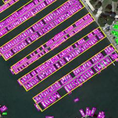
Object Detection in Aerial Images: A Large-Scale Benchmark and Challenges
In the past decade, object detection has achieved significant progress in natural images but not in aerial images, due to the massive variations in the scale and orientation of objects caused by the bird's-eye view of aerial images. More importantly, the lack of large-scale benchmarks has become a major obstacle to the development of object detection in aerial images (ODAI). In this paper,we present a large-scale Dataset of Object deTection in Aerial images (DOTA) and comprehensive baselines for ODAI. The proposed DOTA dataset contains 1,793,658 object instances of 18 categories of oriented-bounding-box annotations collected from 11,268 aerial images. Based on this large-scale and well-annotated dataset, we build baselines covering 10 state-of-the-art algorithms with over 70 configurations, where the speed and accuracy performances of each model have been evaluated. Furthermore, we provide a code library for ODAI and build a website for evaluating different algorithms. Previous challenges run on DOTA have attracted more than 1300 teams worldwide. We believe that the expanded large-scale DOTA dataset, the extensive baselines, the code library and the challenges can facilitate the designs of robust algorithms and reproducible research on the problem of object detection in aerial images.
PDF Abstract


 DOTA 2.0
 ImageNet
 MS COCO
 DOTA
DOTA
 xView
xView
 VisDrone
