Extraction of cropland field parcels with high resolution remote sensing using multi-task learning
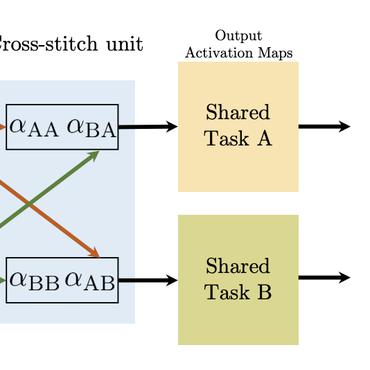
Parcel-level farmland information contains rich spatial distribution and boundary details, which is crucial for digital agriculture and agricultural resource surveys. However, the spatial complexity and heterogeneity of features resulting from high resolution makes it difficult to obtain parcel-level information quickly and accurately. In addition, existing methods do not sufficiently take into account the spatial topological information, particularly for blurred boundaries. Here, we develop a multi-task network model to extract plot-level cropland information. Specifically, the model consists of a cascaded multi-task network with integrated semantic and edge detection, a refinement network with fixed edge local connectivity, and an integrated fusion model. To validate the performance of the model, two typical tests were conducted in Denmark (Europe) and Chongqing (Asia) with high-resolution remote sensing images provided by Sentinel-2 (10 m) and Google Earth (0.53 m) as data sources. The results show that our proposed model outperforms other baseline models and exhibits higher performance. This study is expected to provide important support for the design of new global agricultural information management systems in the future.
PDF Abstract