Search Results for author:
Found 5 papers, 3 papers with code
On the Design of Privacy-Aware Cameras: a Study on Deep Neural Networks
At the same time, we ensure that useful non-sensitive data can still be extracted from distorted images.
Pix2Point: Learning Outdoor 3D Using Sparse Point Clouds and Optimal Transport
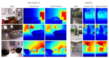
The 3D information was usually obtained from images by stereo-photogrammetry, but deep learning has recently provided us with excellent results for monocular depth estimation.

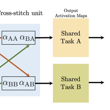
Multi-Task Learning of Height and Semantics from Aerial Images
Aerial or satellite imagery is a great source for land surface analysis, which might yield land use maps or elevation models.
Technical Report: Co-learning of geometry and semantics for online 3D mapping
This paper is a technical report about our submission for the ECCV 2018 3DRMS Workshop Challenge on Semantic 3D Reconstruction \cite{Tylecek2018rms}.


Deep Depth from Defocus: how can defocus blur improve 3D estimation using dense neural networks?
We also investigate the influence of blur on depth prediction observing model uncertainty with a Bayesian neural network approach.