
DenseLiDAR: A Real-Time Pseudo Dense Depth Guided Depth Completion Network
Depth Completion can produce a dense depth map from a sparse input and provide a more complete 3D description of the environment. Despite great progress made in depth completion, the sparsity of the input and low density of the ground truth still make this problem challenging. In this work, we propose DenseLiDAR, a novel real-time pseudo-depth guided depth completion neural network. We exploit dense pseudo-depth map obtained from simple morphological operations to guide the network in three aspects: (1) Constructing a residual structure for the output; (2) Rectifying the sparse input data; (3) Providing dense structural loss for training the network. Thanks to these novel designs, higher performance of the output could be achieved. In addition, two new metrics for better evaluating the quality of the predicted depth map are also presented. Extensive experiments on KITTI depth completion benchmark suggest that our model is able to achieve the state-of-the-art performance at the highest frame rate of 50Hz. The predicted dense depth is further evaluated by several downstream robotic perception or positioning tasks. For the task of 3D object detection, 3~5 percent performance gains on small objects categories are achieved on KITTI 3D object detection dataset. For RGB-D SLAM, higher accuracy on vehicle's trajectory is also obtained in KITTI Odometry dataset. These promising results not only verify the high quality of our depth prediction, but also demonstrate the potential of improving the related downstream tasks by using depth completion results.
PDF Abstract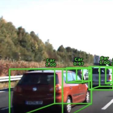


 KITTI
KITTI
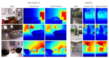
 NYUv2
NYUv2
