Search Results for author:
Found 7 papers, 0 papers with code
Unveiling Ancient Maya Settlements Using Aerial LiDAR Image Segmentation
Manual identification of archaeological features in LiDAR imagery is labor-intensive, costly, and requires archaeological expertise.

UAV-Borne Mapping Algorithms for Low-Altitude and High-Speed Drone Applications
Results indicate that for UAVs with restrictive computing resources, DSOL is the best option.
ROS georegistration: Aerial Multi-spectral Image Simulator for the Robot Operating System
The novelty of this work is threefold: (1) this is the first system to link the massive multi-spectral imaging database of Google's Earth Engine to the Gazebo simulator, (2) this is the first example of a system that can simulate geospatially and radiometrically accurate imagery from multiple sensor views of the same terrain region, and (3) integration with other UAS tools creates a new holistic UAS simulation environment to support UAS system and subsystem development where real-world testing would generally be prohibitive.
Real-Time Surface Fitting to RGBD Sensor Data
This article describes novel approaches to quickly estimate planar surfaces from RGBD sensor data.
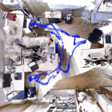
Real-Time RGBD Odometry for Fused-State Navigation Systems
This article describes an algorithm that provides visual odometry estimates from sequential pairs of RGBD images.
 Visual Odometry
Robotics
Visual Odometry
Robotics
Maplets: An Efficient Approach for Cooperative SLAM Map Building Under Communication and Computation Constraints
Maplets are generated in an overlapping manner and used to estimate the transform and uncertainty between those overlapping maplets, providing accurate and compact odometry or delta-pose representation between maplet's local frames.
Compute-Bound and Low-Bandwidth Distributed 3D Graph-SLAM
This article describes a new approach for distributed 3D SLAM map building.
