Search Results for author:
Found 20 papers, 5 papers with code
Probabilistic Image-Driven Traffic Modeling via Remote Sensing
This work addresses the task of modeling spatiotemporal traffic patterns directly from overhead imagery, which we refer to as image-driven traffic modeling.
Handling Image and Label Resolution Mismatch in Remote Sensing
Though semantic segmentation has been heavily explored in vision literature, unique challenges remain in the remote sensing domain.

Revisiting Near/Remote Sensing with Geospatial Attention
We introduce a novel architecture for near/remote sensing that is based on geospatial attention and demonstrate its use for five segmentation tasks.

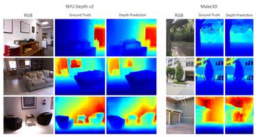
Augmenting Depth Estimation with Geospatial Context
We propose an end-to-end architecture for depth estimation that uses geospatial context to infer a synthetic ground-level depth map from a co-located overhead image, then fuses it inside of an encoder/decoder style segmentation network.
Content-Aware Detection of Temporal Metadata Manipulation
Finally, we demonstrate how the proposed method can be employed to estimate a possible time-of-capture in scenarios in which the timestamp is missing from the metadata.

Learning a Dynamic Map of Visual Appearance
The appearance of the world varies dramatically not only from place to place but also from hour to hour and month to month.
A Structure-Aware Method for Direct Pose Estimation
Direct methods, such as PoseNet, regress pose from the image as a fixed function, for example using a feed-forward convolutional network.


Dynamic Traffic Modeling From Overhead Imagery
Our goal is to use overhead imagery to understand patterns in traffic flow, for instance answering questions such as how fast could you traverse Times Square at 3am on a Sunday.
Single Image Cloud Detection via Multi-Image Fusion
A primary challenge in developing algorithms for identifying such artifacts is the cost of collecting annotated training data.
RasterNet: Modeling Free-Flow Speed using LiDAR and Overhead Imagery
Roadway free-flow speed captures the typical vehicle speed in low traffic conditions.
Learning Geo-Temporal Image Features
We propose to implicitly learn to extract geo-temporal image features, which are mid-level features related to when and where an image was captured, by explicitly optimizing for a set of location and time estimation tasks.
FARSA: Fully Automated Roadway Safety Assessment
An emerging approach for conducting such assessments in the United States is through the US Road Assessment Program (usRAP), which rates roads from highest risk (1 star) to lowest (5 stars).
What Goes Where: Predicting Object Distributions from Above
In this work, we propose a cross-view learning approach, in which images captured from a ground-level view are used as weakly supervised annotations for interpreting overhead imagery.
A Unified Model for Near and Remote Sensing
To evaluate our approach, we created a large dataset of overhead and ground-level images from a major urban area with three sets of labels: land use, building function, and building age.
Understanding and Mapping Natural Beauty
While natural beauty is often considered a subjective property of images, in this paper, we take an objective approach and provide methods for quantifying and predicting the scenicness of an image.
Predicting Ground-Level Scene Layout from Aerial Imagery
We use our network to address the task of estimating the geolocation and geoorientation of a ground image.
![]() Ranked #6 on
Cross-View Image-to-Image Translation
on cvusa
Ranked #6 on
Cross-View Image-to-Image Translation
on cvusa
Detecting Vanishing Points using Global Image Context in a Non-Manhattan World
Our method reverses this process: we propose a set of horizon line candidates and score each based on the vanishing points it contains.
 Ranked #2 on
Horizon Line Estimation
on York Urban Dataset
Ranked #2 on
Horizon Line Estimation
on York Urban Dataset
Horizon Lines in the Wild
The horizon line is an important contextual attribute for a wide variety of image understanding tasks.
 Ranked #2 on
Horizon Line Estimation
on Horizon Lines in the Wild
Ranked #2 on
Horizon Line Estimation
on Horizon Lines in the Wild
Wide-Area Image Geolocalization with Aerial Reference Imagery
We propose to use deep convolutional neural networks to address the problem of cross-view image geolocalization, in which the geolocation of a ground-level query image is estimated by matching to georeferenced aerial images.
Cloud Motion as a Calibration Cue
We propose cloud motion as a natural scene cue that enables geometric calibration of static outdoor cameras.
