Search Results for author:
Found 46 papers, 21 papers with code
Unsupervised Domain Adaptation Architecture Search with Self-Training for Land Cover Mapping
Thus, we proposed a simple yet effective framework to search for lightweight neural networks automatically for land cover mapping tasks under domain shifts.

ChangeMamba: Remote Sensing Change Detection with Spatio-Temporal State Space Model
For the change decoder, which is available in all three architectures, we propose three spatio-temporal relationship modeling mechanisms, which can be naturally combined with the Mamba architecture and fully utilize its attribute to achieve spatio-temporal interaction of multi-temporal features, thereby obtaining accurate change information.
 Ranked #1 on
2D Semantic Segmentation
on xBD
Ranked #1 on
2D Semantic Segmentation
on xBD
Change Detection Between Optical Remote Sensing Imagery and Map Data via Segment Anything Model (SAM)
In this study, we explore unsupervised multimodal change detection between two key remote sensing data sources: optical high-resolution imagery and OpenStreetMap (OSM) data.

Submeter-level Land Cover Mapping of Japan
Deep learning has shown promising performance in submeter-level mapping tasks; however, the annotation cost of submeter-level imagery remains a challenge, especially when applied on a large scale.
SpectralGPT: Spectral Remote Sensing Foundation Model
The foundation model has recently garnered significant attention due to its potential to revolutionize the field of visual representation learning in a self-supervised manner.

Enhancing Monocular Height Estimation from Aerial Images with Street-view Images
Accurate height estimation from monocular aerial imagery presents a significant challenge due to its inherently ill-posed nature.
Flooding Regularization for Stable Training of Generative Adversarial Networks
One of the main approaches to address this problem is to modify the loss function, often using regularization terms in addition to changing the type of adversarial losses.

Land-cover change detection using paired OpenStreetMap data and optical high-resolution imagery via object-guided Transformer
Optical high-resolution imagery and OpenStreetMap (OSM) data are two important data sources for land-cover change detection.
Exchange means change: an unsupervised single-temporal change detection framework based on intra- and inter-image patch exchange
Change detection (CD) is a critical task in studying the dynamics of ecosystems and human activities using multi-temporal remote sensing images.
Real-Time Semantic Segmentation: A Brief Survey & Comparative Study in Remote Sensing
With the success of efficient deep learning methods (i. e., efficient deep neural networks) for real-time semantic segmentation in computer vision, researchers have adopted these efficient deep neural networks in remote sensing image analysis.

SyntheWorld: A Large-Scale Synthetic Dataset for Land Cover Mapping and Building Change Detection
However, when it comes to remote sensing image processing, the creation of synthetic datasets becomes challenging due to the demand for larger-scale and more diverse 3D models.
Understanding Dark Scenes by Contrasting Multi-Modal Observations
Experiments show that our approach can effectively enhance dark scene understanding based on multi-modal images with limited semantics by shaping semantic-discriminative feature spaces.
 Ranked #1 on
Semantic Segmentation
on LLRGBD-synthetic
Ranked #1 on
Semantic Segmentation
on LLRGBD-synthetic

A Simple Framework for 3D Occupancy Estimation in Autonomous Driving
In this work, we present a simple framework for 3D occupancy estimation, which is a CNN-based framework designed to reveal several key factors for 3D occupancy estimation, such as network design, optimization, and evaluation.

OpenEarthMap: A Benchmark Dataset for Global High-Resolution Land Cover Mapping
We introduce OpenEarthMap, a benchmark dataset, for global high-resolution land cover mapping.

Unsupervised Multimodal Change Detection Based on Structural Relationship Graph Representation Learning
Subsequently, the similarity levels of two structural relationships are calculated from learned graph representations and two difference images are generated based on the similarity levels.
EOD: The IEEE GRSS Earth Observation Database
In the era of deep learning, annotated datasets have become a crucial asset to the remote sensing community.
Learning Mutual Modulation for Self-Supervised Cross-Modal Super-Resolution
Self-supervised cross-modal super-resolution (SR) can overcome the difficulty of acquiring paired training data, but is challenging because only low-resolution (LR) source and high-resolution (HR) guide images from different modalities are available.

V4D: Voxel for 4D Novel View Synthesis
The proposed LUTs-based refinement module achieves the performance gain with little computational cost and could serve as the plug-and-play module in the novel view synthesis task.
Decoupled-and-Coupled Networks: Self-Supervised Hyperspectral Image Super-Resolution with Subpixel Fusion
Enormous efforts have been recently made to super-resolve hyperspectral (HS) images with the aid of high spatial resolution multispectral (MS) images.
 Hyperspectral Image Super-Resolution
 Image Super-Resolution
+1
Image Super-Resolution
+1
ES6D: A Computation Efficient and Symmetry-Aware 6D Pose Regression Framework
In this paper, a computation efficient regression framework is presented for estimating the 6D pose of rigid objects from a single RGB-D image, which is applicable to handling symmetric objects.
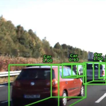
Building Damage Mapping with Self-PositiveUnlabeled Learning
Humanitarian organizations must have fast and reliable data to respond to disasters.
Endmember-Guided Unmixing Network (EGU-Net): A General Deep Learning Framework for Self-Supervised Hyperspectral Unmixing
Over the past decades, enormous efforts have been made to improve the performance of linear or nonlinear mixing models for hyperspectral unmixing, yet their ability to simultaneously generalize various spectral variabilities and extract physically meaningful endmembers still remains limited due to the poor ability in data fitting and reconstruction and the sensitivity to various spectral variabilities.
Interpretable Hyperspectral AI: When Non-Convex Modeling meets Hyperspectral Remote Sensing
Hyperspectral imaging, also known as image spectrometry, is a landmark technique in geoscience and remote sensing (RS).
Fast Hyperspectral Image Recovery via Non-iterative Fusion of Dual-Camera Compressive Hyperspectral Imaging
Specifically, the RGB measurement is utilized to estimate the coefficients, meanwhile the CASSI measurement is adopted to provide the orthogonal spectral basis.
Synthesizing Optical and SAR Imagery From Land Cover Maps and Auxiliary Raster Data
We synthesize both optical RGB and synthetic aperture radar (SAR) remote sensing images from land cover maps and auxiliary raster data using generative adversarial networks (GANs).
Non-local Meets Global: An Iterative Paradigm for Hyperspectral Image Restoration
Non-local low-rank tensor approximation has been developed as a state-of-the-art method for hyperspectral image (HSI) restoration, which includes the tasks of denoising, compressed HSI reconstruction and inpainting.

Joint and Progressive Subspace Analysis (JPSA) with Spatial-Spectral Manifold Alignment for Semi-Supervised Hyperspectral Dimensionality Reduction
Conventional nonlinear subspace learning techniques (e. g., manifold learning) usually introduce some drawbacks in explainability (explicit mapping) and cost-effectiveness (linearization), generalization capability (out-of-sample), and representability (spatial-spectral discrimination).

Learning from Multimodal and Multitemporal Earth Observation Data for Building Damage Mapping
In this study, we have developed a global multisensor and multitemporal dataset for building damage mapping.
More Diverse Means Better: Multimodal Deep Learning Meets Remote Sensing Imagery Classification
In particular, we also investigate a special case of multi-modality learning (MML) -- cross-modality learning (CML) that exists widely in RS image classification applications.


Guided Deep Decoder: Unsupervised Image Pair Fusion
The proposed network is composed of an encoder-decoder network that exploits multi-scale features of a guidance image and a deep decoder network that generates an output image.
Illumination invariant hyperspectral image unmixing based on a digital surface model
Although many spectral unmixing models have been developed to address spectral variability caused by variable incident illuminations, the mechanism of the spectral variability is still unclear.
X-ModalNet: A Semi-Supervised Deep Cross-Modal Network for Classification of Remote Sensing Data
This paper addresses the problem of semi-supervised transfer learning with limited cross-modality data in remote sensing.
Breaking the Limits of Remote Sensing by Simulation and Deep Learning for Flood and Debris Flow Mapping
We propose a framework that estimates inundation depth (maximum water level) and debris-flow-induced topographic deformation from remote sensing imagery by integrating deep learning and numerical simulation.
Learning Convolutional Sparse Coding on Complex Domain for Interferometric Phase Restoration
Interferometric phase restoration has been investigated for decades and most of the state-of-the-art methods have achieved promising performances for InSAR phase restoration.
Hyperspectral Super-Resolution via Coupled Tensor Ring Factorization
In this paper, we propose a new model, named coupled tensor ring factorization (CTRF), for HSR.
Invariant Attribute Profiles: A Spatial-Frequency Joint Feature Extractor for Hyperspectral Image Classification
In this paper, we propose a solution to address this issue by locally extracting invariant features from hyperspectral imagery (HSI) in both spatial and frequency domains, using a method called invariant attribute profiles (IAPs).
Learning Shared Cross-modality Representation Using Multispectral-LiDAR and Hyperspectral Data
Due to the ever-growing diversity of the data source, multi-modality feature learning has attracted more and more attention.
Unsupervised and Unregistered Hyperspectral Image Super-Resolution with Mutual Dirichlet-Net
With this design, the network allows to extract correlated spectral and spatial information from unregistered images that better preserves the spectral information.
Learnable Manifold Alignment (LeMA) : A Semi-supervised Cross-modality Learning Framework for Land Cover and Land Use Classification
In this paper, we aim at tackling a general but interesting cross-modality feature learning question in remote sensing community --- can a limited amount of highly-discrimin-ative (e. g., hyperspectral) training data improve the performance of a classification task using a large amount of poorly-discriminative (e. g., multispectral) data?
CoSpace: Common Subspace Learning from Hyperspectral-Multispectral Correspondences
To achieve accurate land cover classification over a large coverage, we propose a cross-modality feature learning framework, called common subspace learning (CoSpace), by jointly considering subspace learning and supervised classification.
Multisource and Multitemporal Data Fusion in Remote Sensing
The sharp and recent increase in the availability of data captured by different sensors combined with their considerably heterogeneous natures poses a serious challenge for the effective and efficient processing of remotely sensed data.
Non-local Meets Global: An Integrated Paradigm for Hyperspectral Denoising
This is done by first learning a low-dimensional projection and the related reduced image from the noisy HSI.
 Ranked #10 on
Hyperspectral Image Denoising
on ICVL-HSI-Gaussian50
Ranked #10 on
Hyperspectral Image Denoising
on ICVL-HSI-Gaussian50
An Augmented Linear Mixing Model to Address Spectral Variability for Hyperspectral Unmixing
To this end, we propose a novel spectral mixture model, called the augmented linear mixing model (ALMM), to address spectral variability by applying a data-driven learning strategy in inverse problems of hyperspectral unmixing.
Joint & Progressive Learning from High-Dimensional Data for Multi-Label Classification
Despite the fact that nonlinear subspace learning techniques (e. g. manifold learning) have successfully applied to data representation, there is still room for improvement in explainability (explicit mapping), generalization (out-of-samples), and cost-effectiveness (linearization).
Multi-temporal Sentinel-1 and -2 Data Fusion for Optical Image Simulation
In this paper, we present the optical image simulation from a synthetic aperture radar (SAR) data using deep learning based methods.

Hyperspectral pansharpening: a review
In this work, we compare new pansharpening techniques designed for hyperspectral data with some of the state of the art methods for multispectral pansharpening, which have been adapted for hyperspectral data.
